La bataille de Normandie : vue du ciel
La bataille de Normandie vue du ciel
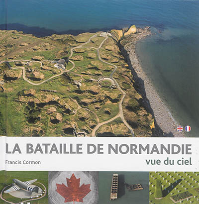
La Bataille de Normandie est l'une des plus grandes batailles de la Seconde Guerre mondiale, et probablement la plus emblématique puisqu'elle s'amorce le 6 juin 1944. Ce fameux « Jour J » par lequel débute le Débarquement sur les côtes normandes. Avec 150 000 hommes, les Alliés parviennent ainsi à ouvrir un nouveau front sur le sol européen, qui s'étend de l'Est du Cotentin jusqu'à l'Ouest du Calvados. Mais la libération de la Normandie ne sera effective
qu'au terme de combats acharnés qui ne prendront fin qu'en août 1944. Sainte-Mère-Église, la Pointe du Hoc, Longues-sur-Mer, Arromanches, Bayeux, Bénouville, la Poche de Falaise, la Bataille de Chambois, Lisieux, Ardouval... Francis Cormon, pilote de paramoteur et spécialiste de photographie aérienne, nous propose une vision inédite du théâtre des opérations.
The battle of Normandy from the air
The Battle of Normandy is one of the greatest battles of the Second World War, and the fact that it started on June 6<sup>th</sup> 1944, this famous « D-Day» which represents the beginning of the Landing on the coasts of Normandy, probably makes it also the most emblematic. Strong of 150,000 men, the Allied Forces manage to open a new front on European grounds. It starts to the East of the Cotentin and reaches to the West of Calvados. But the liberation of Normandy will only
happen at the end of fierce battles which only concluded in August 1944.
Sainte-Mère-Église, the Pointe du Hoc, Longues-sur-Mer, Arromanches, Bayeux, Bénouville, the Pocket of Falaise, the Battle of Chambois, Lisieux, Ardouval... Francis Cormon, a paraglider pilot and aerial photography specialist, offers a view of the battle field never seen before.